

Hurricane Harvey
Flooding and Rainfall Update in Montgomery County
The National Weather Service has issued a Flash Flood Warning for Montgomery County until Saturday, August 26 at 11:30 a.m. and a Tornado Watch until 1 p.m. CDT.
Update: Flash Flood Warning extended to 2:15 p.m. In Montgomery County
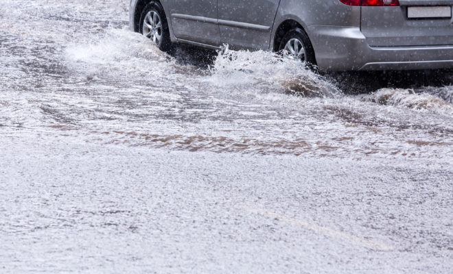
Please do NOT drive through flooded roadways. Road beds may be washed out under flood waters. Turn Around Don’t Drown!
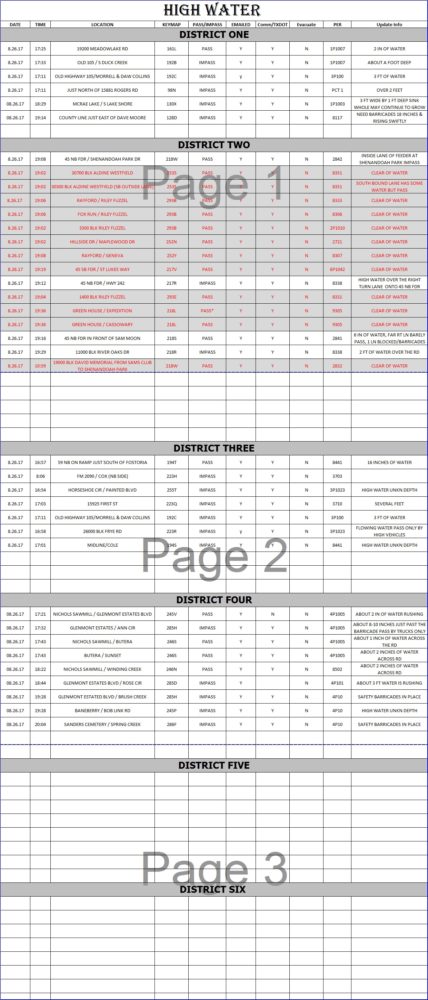
High Water Locations via Houston TransStar
| IH-45 Northbound At FM-1097 in Montgomery County | 3 Frontage Road Lanes | Verified at 10:11 AM today | |
| 3 Frontage Road Lanes,Exit Ramp | Verified at 9:21 AM today | ||
| 2 Frontage Road Lanes | Verified at 10:18 AM today | ||
| 3 Frontage Road Lanes | Verified at 9:20 AM today |
Montgomery County Office of Homeland Security and Emergency Management reported current road conditions and water over roads. Currently W Panther Creek/Woodlands Parkway has received 3-4 inches of rain but still passable as of 8:26 a.m.
Rainfall over last 12 hours in Montgomery County via National Weather Service Houston/Galveston TX
Location Amount Time Date Lat/Lon
Hufsmith                     4.88 in   0828 AM 08/26   30.17N/95.54W
1 SE Chateau Woods           3.77 in   0900 AM 08/26   30.15N/95.41W
5 NNE Tomball                3.73 in   0859 AM 08/26   30.18N/95.60W
Oak Ridge North              3.61 in   0855 AM 08/26   30.17N/95.44W
3 WNW The Woodlands          3.57 in   0858 AM 08/26   30.18N/95.54W
2 ENE Montgomery             3.45 in   0857 AM 08/26   30.41N/95.66W
Lake Creek At Honea-egypt Ro 3.43 in   0846 AM 08/26   30.25N/95.58W
Dobbin                       3.42 in   0851 AM 08/26   30.38N/95.76W
Fm 2978                      3.40 in   0841 AM 08/26   30.13N/95.60W
4 NW The Woodlands           3.30 in   0857 AM 08/26   30.21N/95.54W
Tomball 1n                   3.12 in   0832 AM 08/26   30.12N/95.65W
New Waverly 4 S              2.84 in   0853 AM 08/26   30.49N/95.51W
2 W Stagecoach               2.81 in   0852 AM 08/26   30.15N/95.76W
1 WNW The Woodlands          2.71 in   0858 AM 08/26   30.17N/95.51W
4 N Tomball                  2.71 in   0847 AM 08/26   30.16N/95.63W
2 NE Spring                  2.61 in   0847 AM 08/26   30.09N/95.36W
3 ENE Pinehurst              2.45 in   0847 AM 08/26   30.22N/95.66W
Lake Conroe Nr Conroe        2.29 in   0852 AM 08/26   30.36N/95.56W
Flamingo Lake                1.97 in   0853 AM 08/26   30.45N/95.70W
3 E Spring                   1.95 in   0854 AM 08/26   30.07N/95.33W
Spring                       1.84 in   0800 AM 08/26   30.13N/95.48W
4 NNW Shenandoah             1.84 in   0803 AM 08/26   30.24N/95.48W
Panther Branch@gosling Rd    1.67 in   0800 AM 08/26   30.19N/95.48W
Willis                       1.60 in   0854 AM 08/26   30.42N/95.49W
Union Grove                  1.46 in   0852 AM 08/26   30.54N/95.75W
Caney Creek At Splendora     1.42 in   0854 AM 08/26   30.26N/95.30W
Wf San Jacinto               1.40 in   0830 AM 08/26   30.24N/95.46W
East Fork San Jacinto River  1.35 in   0846 AM 08/26   30.15N/95.12W
4 W Willis                   1.22 in   0852 AM 08/26   30.42N/95.55W
Patton Village               1.16 in   0843 AM 08/26   30.21N/95.50W
5 W Panorama Village         0.01 in   0656 AM 08/26   30.37N/95.59W
Montgomery County Office of Emergency Management Update on August 26 at 9:30 p.m. for water over roads.
If flooding occurs follow these safety rules:
• If flooding occurs, get to higher ground. Get out of areas subject to flooding. This includes dips, low spots, canyons, washes etc.
• Avoid areas already flooded, especially if the water is flowing fast. Do not attempt to cross flowing streams. Turn Around Don’t Drown
• NEVER drive through flooded roadways. Road beds may be washed out under flood waters. Turn Around Don’t Drown
• If your vehicle is suddenly caught in rising water, leave it immediately and seek higher ground.
• Be especially cautious at night when it is harder to recognize flood dangers.
• NEVER go around barricades or road closures.
Learn more about Flood Safety at Flood Safety during Hurricane Harvey